What the Grand Old Man’s bizarre reconfiguration of Homer can tell us about our empirically real world.
As William Ewart Gladstone recognized from his reading of Homer, much of our mental mapping of the world is fanciful; all of it is provisional.
For example, I can recall the brow-furrowing effort I had to make to understand just exactly what and where Devon was when, aged five, one of my classmates told us her family was moving ‘down’ there. Assisted perhaps by the clarifications of the teacher, and the gravitational pull of ‘Heaven’ which, this being a Catholic primary school, was much discussed in relation to the death of pets, I can still picture the image I formed of it, a dislocated demi-paradise of cream teas, floating in some lower sky, a mezzanine to the main body of the world.
I do not wish to draw (fanciful) parallels between my own infant comprehension of the world and that of the Greeks, but it seems natural to wonder how an imaginative and intelligent citizen of the Bronze Age – Homer, for instance – might have mentally configured the world in which he lived and of which he sang, given that he had neither a map of any part of that world nor an idea of map in general.
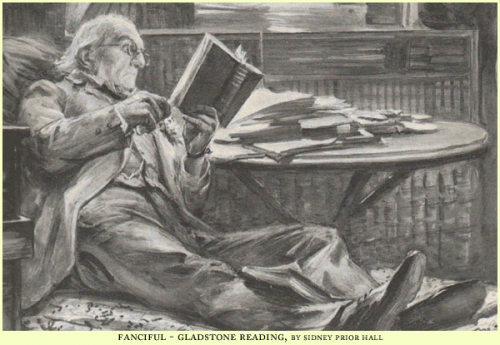
Gladstone believed that scholarship, in his own estimable person, could supply Homer’s deficiencies– that Homer’s mental image of the world could be not only imagined, but plotted. And thus in 1858, between stints as Chancellor of the Exchequer in Palmerston’s governments, he found time to publish his three-volume Studies on Homer and the Homeric Age, in which he produced an ingenious and fairly presumptuous map of the Homeric world.
There had been many prior attempts to pin the geography of The Odyssey (and, to a lesser extent, The Iliad) to the actual geography of the Mediterranean. But Gladstone, while accepting the historical and geographical veracity of the Homeric tales, saw that Homer’s geographical knowledge was of two distinct varieties, which he labelled Inner and Outer, and that the differential between them precluded any precise real-world correspondences, at least where the outer was concerned.
The Inner Geography was the world as known to the Greeks through personal exploration, and comprised the Aegean and mainland Greece as far south as Crete and as far east as the littoral of Asia Minor; but not at this point as far West as Magna Grecia (the first Greek colonies in Southern Italy were founded in the eighth century, but Gladstone was assuming a much earlier date for the composition of the Homeric corpus – perhaps the fourteenth century). It corresponded to the geography attested to in The Iliad (and especially in the Catalogue of Ships) and the parts of The Odyssey centred on Ithaca.
The Outer Geography was the world known only through the dubious conflicting second-hand tales of Phoenician sailors – rumours of monsters and clashing rocks, islands of cyclopes and sorcerers – and it corresponded to most of the rest of The Odyssey.
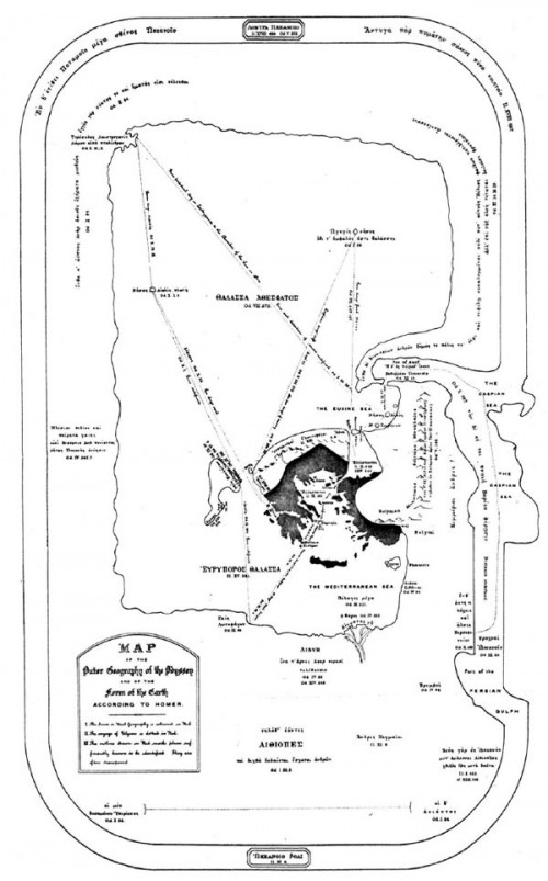
Gladstone’s contention was that for Homer, the Outer Geography is not qualitatively different from the Inner; it lies on a spectrum of attested fact, and if it is merely provisional in nature, then this is true of all geographical knowledge, historically considered. Homer’s geography is therefore neither pure fancy nor proper fact; and if it cannot be tied to the topographical realities of the Mediterranean as we know them, nevertheless an abstractly configured mental map, tethered at various points to a known world, could be reconstructed, as follows:
The map shows the Outer Geography. The world is conceived of as an oval shield, circumbound by the World Ocean. Greece – the black mass at the centre (coloured red in the original) – and the Nile Delta are correctly situated; Italy can be made out to the west of Greece, and the coastline of ‘Phoenicia’ to the east; the Adriatic gives access to a vast sea stretching to the north of Thrace, which allows adequate play for Odysseus’s wanderings as derived from the wind directions and travel time in days noted in The Odyssey.
Needless to say, none of Gladstone’s speculations regarding Homer’s geographical understanding have any current validity (and they were in fact almost universally rejected at the time of publication), partly because of his erroneous assumptions regarding the manner of oral composition and transmission of the text, and partly because he had in his own head a hyper-rationalist version of cognitive psychology according to which it was not possible to ‘know’ geography without having first studied maps.
But it is worth recalling that our own mental Atlases are not limited by the procrustean projections of modern cartography. A city on a map – New York, Milan, Norbiton – has to be triangulated with our experience of it, the tales we have heard tell of it. It will be provisional, not because places change, but because our understanding of them does. Gladstone’s bizarre reconfiguration of the actual world on Homer’s behalf (the work, it should be noted, of a future Prime Minister who would attempt to use the British Fleet to locate Atlantis in the South Atlantic) was if nothing else sensitive to the groping engagement of the imagination with the empirically real world – which is, I loosely suppose, what Epic and other literatures amount to.


I recall reading somewhere that Gladstone believed the Ancient Greeks were colour-blind, because there are so few colour-words in Homer.
quite so – ” …the organ of color and its impressions were but partially developed among the Greeks of the heroic age”
Given the slightness of his evidence (they called the sea wine-dark), his conclusions (that there was something wrong with their eyes) are speculative, to say the least.
However, it doesn’t stop there. Hunting for the quotation above, I found this (on The Straight Dope, here http://www.straightdope.com/columns/read/449/could-early-man-only-see-three-colors), which I quote in full for oddity value.
“More recent research, however, suggests that color terminology may not be so arbitrary after all. Brent Berlin and Paul Kay (Basic Color Terms: Their Universality and Evolution, 1969) … suggest that there is a remarkable degree of uniformity in the way different cultures assign color names. In a study of 98 languages from a variety of linguistic families, they found the following “rules” seem to apply:
1. All languages contain terms for white and black.
2. If a language contains three terms, then it contains a term for red.
3. If a language contains four terms, then it contains a term for either green or yellow (but not both).
4. If a language contains five terms, then it contains terms for both green and yellow.
5. If a language contains six terms, then it contains a term for blue.
6. If a language contains seven terms, then it contains a term for brown.
7. If a language contains eight or more terms, then it contains a term for purple, pink, orange, grey, or some combination of these.”
wonderful writing Toby, and my first experience of the word procrustean!
Your piece put me in mind of Donald Rumsfeld’s observation : “As we know, there are known knowns; there are things we know we know. We also know there are known unknowns; that is to say we know there are some things we do not know. But there are also unknown unknowns — the ones we don’t know we don’t know.”
Thanks Worm – Yes, difference being that Gladstone not only knew what the unknown unknowns were, he was able to locate them on a map. No wonder he always got picked to be PM.
Gladstone was a truly strange man. Even stranger than his sometime oppo, Disraeli, which is good going. He was quite mad quite a lot of the time. There’s a very entertaining book comparing and contrasting the two:
http://www.amazon.co.uk/Lion-Unicorn-Gladstone-Disraeli/dp/1844133125/ref=tmm_pap_title_0
Super stuff, Toby, and thanks also for the colour comment.
“a dislocated demi-paradise of cream teas, floating in some lower sky, a mezzanine to the main body of the world” – actually that’s not a bad description of Devon, apart from Ilfracombe of course.
Thanks Brit – I finally worked out where and what it was and paid it a couple of visits. It was very pleasant on the whole. Don’t know about demi-paradise. I got very wet walking from Dawlish to Teignmouth a couple of years ago, and then sat in my damp clothes in a foul pub wondering what it was all about.
I remember a decent pub in Dawlish though, called the Exeter.
Roy Jenkins’s biography of Gladstone is quite long, as suits Gladstone’s very long career, but is very good reading. Martin Gardner, in the essay “Mathematics and Folkways”, collected in The Night is Large, touches on the history of the color business.