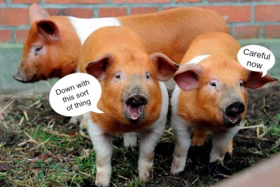
A post in honour of our new footballing overlords this week, as the Wikiworm presents another unusual wikipedia article
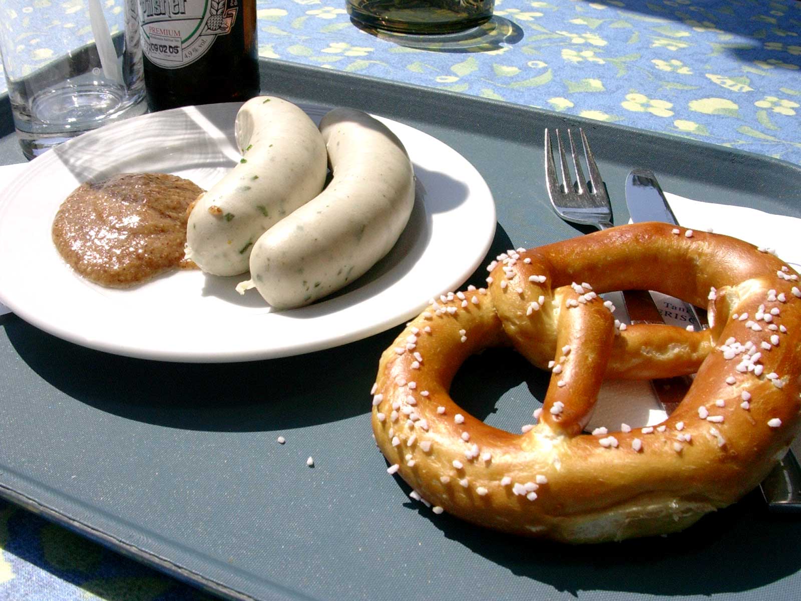
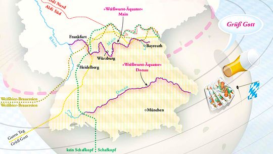
The Weißwurstäquator (literally: white sausage equator) is a humorous term describing the supposed cultural boundary separating Southern Germany, especially Bavaria, from Central Germany.
It is named for the Weißwurst sausage of Bavaria. There is no precise definition of the Weißwurstäquator; it is sometimes taken to correspond with the linguistic boundary known as the Speyer line separating Upper German from Central German dialects, roughly following the Main River. It is sometimes taken to run further south, more or less along the Danube, or between the Main and the Danube, roughly along the 49th parallel north circle of latitude.
In the UK, an equivalent cultural boundary term is ‘north of the Watford Gap‘.


It is said that, in Upper and Lower Franconia, there are more breweries than in the rest of Europe combined. Could it be that, like Linie Aquavit, the beer is only fit for drinking once it has crossed, then re-crossed the Weißwurstäquator.
Goethe was less specific in his criticism of his fellow Germans, he simply thought many Northern Germans were a bunch of trailer park trash. With, of course, the exception of Schiller whom he thought an awkward old tosser.
Inter-regional rivalries are as nothing compared to the Makum-Geordie dispute….“wheeze keys are theeze” versus “bliddy midden ridden” they chant, as they ram raid each others retail premises,
The mother of a neighbor, born and raised in the German-speaking part of Switzerland, says that the Swiss speak of a “Roestigraben” separating the German from the French cantons. And by gum, it has is own Wikipedia entry.,
I suppose the American version is the Mason-Dixon line? (Although that’s a ‘real’ line)
I don’t think the Mason-Dixon line is in the same category. That was an official political boundary, like the 38th parallel.
These informal demarcation lines can be found in many places. Just think of “the other side of the tracks.” Where I used to live, there is a line which doesn’t have a name (yet), although it follows along a road called Hollow Road.
For more than a century there was a road called Sodom Road which crossed Hollow Road. Sodom Road got its name – or so the story goes – from a brothel at the corner of Sodom and Hollow in the 18th century.
As 1980’s exurban gentrification set in, Sodom Road north of Hollow became built up with middle-class ranch homes, “log” homes from kits, with all the conveniences, and “Colonials.” Sodom Road south of Hollow was (and is today) lined with immobile mobile homes, usually with a junked car or Harley Davidson (or both) parked in the front yard, and a paint-deprived doghouse to which was chained a German Police Dog (I think that across the pond, during one of the big wars, you started calling them “Alsatians”) pacing and snarling or snoozing on the roof.
The folks living north of Hollow Road, embarrassed by giving their address as Sodom Road, asked the town board to change the name to Walnut Lane (how anodyne can you get?) The town organized a referendum of Sodom Road residents. About 100% of those north of Hollow Road voted for the name change, while the same percentage south of Hollow liked the name as it was. The town fathers, in their Solomonic wisdom, changed Sodom Road to Walnut Lane north of Hollow, but kept the original name south of Hollow.
I will freely admit an almost total lack of knowledge in this area – but isn’t the Mason-Dixon line, whilst being an officially delineated division when it was made, also now regarded as a sort of unofficial cultural line that separates the ‘north’ and the ‘south’ (Dixie)?
Mason-Dixon line. Hmm, yes, you’re right. The Mason-Dixon line was an unofficial cultural line. Back in the middle of the last century, it was a common delineation that everyone was familiar with. If the phrase appeared in a song — and it did in more than one — the meaning was clear. Now — not so much. The fact that that that hadn’t occurred to me kind of indicates that it’s losing its gist. Maybe — just guessing now — that began to happen in the civil rights era. The South no longer is homogeneous. Atlanta, for example, no longer has that deep South flavor; and Florida is full of retired New Yorkers and Cubans.
The Mason-Dixon line divides Pennsylvania and Maryland. I believe that the portion the two surveyors ran was not especially long, but the name survives. Indeed Maryland was a slave-holding state and Pennsylvania was not; but the two states have never been anything like internally homogeneous. And Maryland did not secede from the Union during the Civil War, though it contributed regiments to both armies.
The origins of the expression Dixie are obscure and disputed: In New Orleans they will tell you that it had to do with $10 (or maybe 10 franc) bills issued by a local bank and helpfully marked “Dix” for locals who hadn’t yet learned English.
As a Canadian who has crossed the Mason-Dixon line many times, I can assure everyone that, although perhaps a hundred miles or so too far north, it is indeed a sharp cultural divide, with contrasting delights and perplexities on each side.
A sometime co-worker, a Virginian, told of a congressman from a southern portion of the state, who would toss off a drink every time he crossed the Rappahannock River on his way back south, regarding that as the boundary between Yankee encroachment and the true Virginia. I have never traveled directly from the Mason-Dixon line to the Rappahannock, but a Google Maps itinerary from Gettysburg, Pennsylvania (just north of the line) to Fredericksburg via US 15 and I-95 is 129 miles, very close to your estimate.
George, your returning southern congressman is living proof of the divide. Surely it is culturally very southern to celebrate crossing the line with a solitary stiff drink, perhaps silently toasting the veterans of the War of Northern Aggression. A returning northerner would probably go for a workout or treat the family to dinner at Denny’s.
Peter: First, as Everett Dirksen said of a less fraught (non-shooting) form of politics, “the winners never remember, and the losers never forget.” For the hypothetical northern congressman there is no reason to distinguish the Rapahannock at Fredericksburg from the Raritan at New Brunswick. Second, the sociology and geography of alcohol in the US is, as you must know, an involved and difficult subject. Pennsylvania and Maryland are excellent examples. Third, people tend to write of the War of the Rebellion as if it were Friends v. Duck Dynasty. In fact, the US was predominantly rural, north and south, through the end of WW I.
J Meades divides Europe north/south into Beer and Wine – fundamentally different souls.
the UK could have a Cider Line, or perhaps a Pie Equator
A sort of division by gastric juices or, as Brian Sewell would proclaim, them northerners, eh!
None of this inter-regional competitiveness bothers me in the least, as long as, collectively, we, and I mean all of we, absolutely hate the French.
Except of course the TDF and the Savoy, savwah as the pretentious egotistical, garlic reeking sods would say.
Isn’t North vs South in England delineated by the default meal that’s served as ‘fish and chips’? Cod cooked in veg fat vs haddock cooked in beef dripping and served with mushy peas? The Haddock Line? The Mushypeaquator?
Re Sodom Road being renamed as Walnut Lane – shame the inhabitants of the original Sodom had never heard of re-branding. Would God have smitten Walnutville?
Of course one of the biggest cultural divides in the UK is between West Londoners and others in the capital. Bit like the Lannisters compared to the rest of Westeros.
In his wonderful book The Flutes of Autumn — the best short memoir I know — Peter Levi suggests that these mysterious cultural boundaries have older, tribal origins:
“It may be that the old underlying map of tribal England, which in its cruder boundaries you can still feel today, has not been eroded by time, but intensified. Those mysterious boundaries that marketing surveys discover between preferences for different food or drink still correspond to the tribal divisions of Britain; so do the regions of each traditional way of cooking. So does the style of countryside and architecture.”
Sometimes I wonder if the real divide isn’t in fact geological; between the ‘highland’ England that lies north and west of a line drawn roughly from the Exe estuary to the Humber, and ‘lowland’ England to the south and west. That would put Devon, Cornwall, and parts of Somerset in the ‘north’ and most of Yorkshire in the ‘south’.
would this particular line not also delineate the country into ‘celtic’ and ‘viking/saxon’?
Late again, but one should note Australia’s use of the ‘rabbit-proof fence’: ‘beyond’ this denotes the end of civilization; as for that matter does ‘back of Bourke’.